$4-M Boost Puts Ipswich’s Second Bremer River Crossing One Step Closer

A long-awaited second crossing over the Bremer River in central Ipswich has moved a significant step closer to reality, with $4 million secured to fund a Detailed Business Case for the proposed new bridge.


Read: Cracks Force Speed Limit Drop on Major Ipswich Highway Bridge


Ipswich City’s local officials welcomed the funding announcement on Friday 27 February, describing it as the commencement of an important project that the community has pushed for over more than a decade. 

With a Preliminary and Strategic Business Case already completed, the latest injection of funds secures the critical next planning phase, the Detailed Business Case, which will lay the groundwork for what could eventually become the city’s second inner-city river crossing.

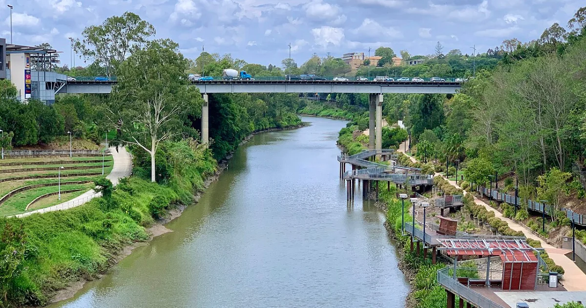
For daily commuters and residents who know central Ipswich well, the need for another bridge is no mystery. The David Trumpy Bridge currently stands as the only inner-city crossing over the Bremer River, carrying the full burden of traffic moving through a city that has grown substantially in recent years. The broader Ipswich corridor has experienced significant population growth in recent years, adding pressure to roads funnelling toward a single crossing point.

Photo credit: Google Street View

Ipswich Mayor Teresa Harding said the new crossing had been on the community’s radar for a long time. “A second inner city river crossing had been on the Ipswich community’s wish list for more than a decade,” Mayor Harding said. 

Beyond easing peak-hour gridlock, Mayor Harding pointed to flood resilience as one of the most compelling reasons to push ahead. Anyone who has lived through Ipswich’s major flood events knows how vulnerable a city can become when it relies on a single crossing. “The second crossing will play a critical role in improving flood immunity and strengthening the resilience of our transport network,” she said.

There’s also a broader vision for what a second bridge could mean for Ipswich’s city centre. Mayor Harding noted it would help “unlock the full potential of our CBD by diverting unnecessary through-traffic and easing congestion on the existing David Trumpy Bridge.”

Transport and Main Roads Minister Brent Mickelberg said the funding allows the project to move into the next phase which is the Detailed Business Case.

“Supporting Ipswich City Council’s planning work for a second bridge over the Bremer River in central Ipswich demonstrates our commitment to delivering what we said we would during the election.”


Read: Bremer River Flooding Update: Water Levels Receding After Cyclone Alfred


The $4 million investment forms part of the State’s Safer Roads, Better Transport initiative.

It’s worth noting that a Detailed Business Case is still a planning document. Further planning, approvals, and a construction funding commitment would all be required before any building could begin. 

Published 9-March-2026

Bremer River Flooding Update: Water Levels Receding After Cyclone Alfred

Ipswich residents have begun recovery efforts as floodwaters from the Bremer River continue to recede following Tropical Cyclone Alfred. Council crews and emergency services are assessing the damage, clearing debris, and restoring access to affected areas.


Read: Springfield Lakes on Alert as Tropical Cyclone Alfred Approaches


With the river level steadily falling, officials are working to evaluate the extent of the flood damage. Ipswich Mayor Teresa Harding provided an update on Tuesday morning, stating: “This morning the Bremer River is falling after peaking at 11.47 metres at midnight. There has been inundation across several roads and suburbs, and as the water recedes, we will be able to assess how many properties have been impacted.”

Bremer River
Photo credit: Bureau of Meteorology

Ipswich was on high alert as the Bremer River experienced major flooding following Tropical Cyclone Alfred. However, there may be some relief for residents as water levels begin to recede, according to the Bureau of Meteorology.

A flood warning issued at 5:21 a.m. on Tuesday, 11 March, confirmed that the Bremer River at Ipswich peaked at 11.47 metres around midnight, just below the major flood level of 11.70 metres. As of this morning (11 March), the river has fallen to 10.67 metres and continues to drop. It is expected to fall below the moderate flood level of 9.00 metres later today.

While flooding has caused road closures and impacted several suburbs, the situation remains less severe compared to previous historical events. The February 2022 flood peaked at 16.70 metres, the 2011 flood at 19.4 metres, and the 1974 flood at 20.70 metres. The worst recorded flood in Ipswich occurred in early 1893, with the Bremer River reaching a staggering 24.50 metres.

Bremer River – (7 Mile Bridge) Ipswich Rosewood Rd, Jeebropilly (Photo credit: Ipswich Flood Cameras)

Local reports indicate that around 30 properties in the Ipswich area have been affected by floodwaters. A resident in Wulkuraka shared that while some areas saw flooding, homes across the railway tracks appeared to be safe.

Bremer River
Bremer River Trib – Junction Rd (near Albatross Av) Karalee (Photo credit: Ipswich Flood Cameras)

Authorities continue to monitor conditions as clean-up efforts begin. Residents are advised to stay updated with official warnings and exercise caution in flood-affected areas.


Read: Flood Tuff Devices Installed in Goodna


Council Services and Facilities Update

Following overnight heavy rainfall, here’s the latest update on council services and facilities. Please note that changes may occur with shifting weather conditions.

Waste Collection:

  • Catch-up waste collection for suburbs affected on 6–7 March is underway. Leave your red-lidded bin out for collection.
  • Scheduled red bin services will proceed as planned today.
  • Green bins scheduled for collection today should be placed out.
  • Yellow bins scheduled for today will not be collected.

Facilities and Services Open:

  • Riverview Resource Recovery Centre
  • Ipswich City Council customer service centres
  • Ipswich Central Library (limited services)
  • Ipswich Visitor Information Centre

Closed:

  • Rosewood Resource Recovery Centre
  • All library branches except Ipswich Central Library
  • Council-managed community centres
  • Queens Park Environment Centre
  • Ipswich Civic Centre, Ipswich Art Gallery, Studio 188, North Ipswich Reserve Corporate Centre, and Fire Station 101
  • Nerima Gardens, Queens Park
  • Council-owned swim centres
  • Ipswich Pound and Animal Management
  • Sporting grounds (until further notice)
  • The following nature estates:
    • Purga Nature Reserve, Flinders-Goolman Conservation Estate, Hillview Drive Reserve, White Rock – Spring Mountain Conservation Estate, Haig Street Quarry Conservation Reserve, Denmark Hill Conservation Park, Colleges Crossing Reserve

Keep track of the latest developments post-Cyclone Alfred:

Published 11-March-2025